Leveraging Open Geodata for Decision Making in Agriculture, Landscape, Climate, and Water
Following the Open Geodata Challenge from 2022, the G4AW programme supported efforts to explore how open-access satellite and geodata can enhance decision-making in sustainable and climate-resilient agriculture, landscape management, and water resources.
With support from the Netherlands Space Office, this initiative brought together Dutch embassies, local advisors, NGOs, and geodata experts from eLEAF, Mapworks, and 52impact in 2024. Together, we worked in Egypt, Jordan, Kenya, Mozambique, and South Africa to explore how geospatial data can address the specific information needs of local organizations.
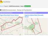
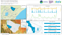
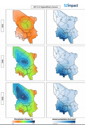
Through these collaborations, we demonstrated how open geographic information can support key areas such as water availability, quality, climate adaptation, erosion management, and landscape conservation—each essential for food security. These demonstrations, tailored to local needs, highlighted the potential of geodata for conducting feasibility studies, defining project scopes, and improving monitoring and evaluation. The feedback received has informed service improvements and contributed to developing a roadmap for future applications.
Resources:
Introduction to webinar (presentation by Netherlands Space Office)
Summary of demonstrations (presentation by 52impact, Mapworks and eLEAF)